California’s roads, infamous for their high accident rates, present a significant safety challenge. The I-5 Corridor and the 405 Freeway are particularly perilous, plagued by severe congestion and complex interchanges. Issues such as distracted driving and outdated infrastructure further exacerbate risks. Especially, segments of the 101 Freeway and I-8 also see frequent collisions. Understanding these patterns is essential for strategic improvements and enhancing road safety. What makes these routes so dangerously unique?
The Treacherous I-5 Corridor
Despite its significance as a major transportation artery, the I-5 corridor in California presents a range of hazards that contribute to its reputation for danger. Analyzing I-5 safety concerns reveals that high accident rates are often linked to fluctuating traffic patterns. Data indicates that the corridor, stretching over 800 miles, experiences congestion during peak hours, increasing the likelihood of collisions. Weather conditions, particularly fog and rain in the Central Valley, further exacerbate these risks. Studies show a correlation between these environmental factors and a spike in accident frequency. Additionally, infrastructure challenges, such as narrow lanes and outdated signage, impair driver response times. This combination of factors necessitates strategic improvements to enhance safety and reduce the corridor’s accident rates.
Navigating the 405 Freeway in Los Angeles
How does the infamous 405 Freeway in Los Angeles maintain its status as one of the most congested and challenging roadways in the United States? Data indicates the freeway handles over 379,000 vehicles daily, with peak hours stretching the congestion further. Heavy traffic coupled with complex interchanges creates a high-risk environment. Frequent lane changes, driven by the need to access exits and on-ramps, often result in abrupt braking and increased collision probability. The freeway’s design, featuring multiple lanes in both directions, exacerbates the issue, leaving little room for error. Analysis shows that sections near LAX and Westwood experience the highest traffic density. Consequently, minor incidents can cascade into significant delays, reinforcing the 405’s reputation for congestion and difficulty.
The Perils of the Pacific Coast Highway
The Pacific Coast Highway, renowned for its breathtaking views, is also notorious for its hazardous driving conditions. This iconic route, officially known as California State Route 1, stretches over 650 miles along the Pacific Coast. Data from the California Highway Patrol indicates a troubling pattern: a high incidence of accidents, particularly in segments with sharp curves and steep cliffs. The highway conditions are exacerbated by fog, rain, and landslides, which frequently impair visibility and road stability. Analysis of accident reports reveals that these environmental factors, combined with driver inattention, are primary contributors to crashes. Importantly, the stretch between Big Sur and San Luis Obispo shows a spike in incidents, suggesting a need for enhanced safety measures and driver awareness campaigns.
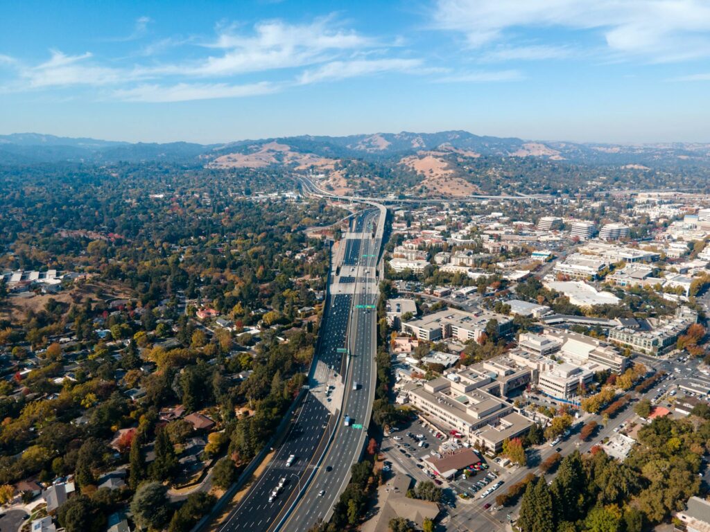
San Francisco’s Infamous 101 Freeway
San Francisco’s 101 Freeway is notorious for its high traffic congestion, with peak periods extending over several hours and average speeds falling below 20 mph. Data from the California Highway Patrol indicate that certain segments, such as the stretch between Cesar Chavez Street and the I-80 interchange, consistently rank among the top accident zones. Contributing factors include complex on-ramps and off-ramps, limited visibility, and frequent lane changes, which compound the risks for motorists.
High Traffic Congestion Risks
Despite its scenic views and proximity to Silicon Valley, the 101 Freeway in San Francisco is notorious for severe traffic congestion, posing considerable risks to commuters. During rush hour, the highway experiences a 30% increase in vehicle density, according to recent transportation data. This uptick in traffic leads to prolonged travel times and heightened stress levels among drivers. Additionally, distracted driving incidents are troublingly frequent, with a report indicating that 15% of accidents are attributed to drivers not paying attention. The combination of high traffic volume and distracted driving markedly raises the risk of collisions. In addition, the freeway’s design with multiple on-ramps and limited visibility in certain sections exacerbates congestion issues, making it a critical area for traffic management and safety improvements.
Frequent Accident Zones Identified
Amid the bustling cityscape of San Francisco, certain stretches of the 101 Freeway emerge as frequent accident zones, demanding careful analysis and attention. Data reveals that the section between Cesar Chavez Street and the I-80 interchange is particularly notorious. Contributing factors include frequent accident causes such as abrupt lane changes and tailgating, exacerbated by dense traffic conditions. Driver behavior, characterized by impatience and distraction, further compounds the risk. Statistical analysis shows a significant correlation between peak travel times and increased collision rates. The complexity of merging lanes and rapid speed shifts requires heightened vigilance. Thorough understanding of these dynamics is essential for implementing targeted safety measures, thereby mitigating the high incidence of accidents on this critical urban artery.
The Challenges of Highway 99
Highway 99, often considered one of California’s most perilous thoroughfares, presents a myriad of challenges that contribute to its high accident rates. Poor road maintenance plays a significant role; the highway frequently exhibits potholes, uneven surfaces, and inadequate signage, exacerbating the risk of collisions. Data from the California Department of Transportation highlights that over 40% of Highway 99 is in dire need of repair. Additionally, driver distractions remain a critical factor. The proliferation of mobile device usage has resulted in a 12% increase in accidents over the past five years. Furthermore, the surrounding agricultural landscape contributes to visual distractions, diverting drivers’ attention. These issues collectively underscore the urgent need for targeted interventions to enhance safety on this hazardous route.

The Sierra Nevada Mountain Roads
The Sierra Nevada Mountain Roads present significant hazards for drivers due to their unpredictable weather conditions and steep elevations. Data indicates that snowfall and icy surfaces contribute to a high incidence of weather-related accidents, with adverse weather being a factor in approximately 30% of crashes in the region. Additionally, the challenging elevations, which can exceed 7,000 feet, exacerbate the risk of mechanical failures and driver fatigue, compounding the danger of these routes.
Weather-Induced Driving Hazards
When traversing the Sierra Nevada mountain roads, drivers face significant weather-induced hazards that can compromise safety. Rainy conditions contribute to slick road surfaces, reducing tire traction and increasing stopping distances. According to California Highway Patrol data, wet pavement is a factor in approximately 22% of weather-related accidents in this region. Foggy visibility further exacerbates risks, obscuring drivers’ sightlines and making it difficult to anticipate road curves and oncoming vehicles. Federal Highway Administration reports indicate that nearly 15% of accidents in mountainous areas occur during foggy conditions. This combination of rain and fog requires heightened driver vigilance and slower speeds. Using fog lights and maintaining a safe following distance are critical measures to navigate these potentially treacherous roads safely.
Challenging Roadway Elevations
How do the steep elevations of the Sierra Nevada mountain roads impact driver safety? The Sierra Nevada roads pose significant challenges due to their steep inclines and winding curves. These features demand heightened driver alertness and vehicle performance. According to the California Highway Patrol, accident rates increase by 20% on these mountainous routes compared to flat terrain. Steep inclines test vehicle braking systems, leading to potential brake failures, while winding curves reduce visibility and reaction time. This combination of factors elevates the risk of head-on collisions and rollovers. Data from the Federal Highway Administration indicates that 40% of accidents on such roads occur at curves. Effective risk mitigation requires enhanced road signage, speed regulation, and driver education focused on mountainous driving conditions.
Sacramento’s Dangerous Interstate 80
Why does Interstate 80 in Sacramento rank among the most perilous roads in California? Data indicates that Sacramento traffic on I-80 experiences significant congestion, contributing to elevated accident rates. According to the California Highway Patrol, I-80 accidents in this region are frequently attributed to high traffic volumes, with over 160,000 vehicles traversing daily. The corridor’s design, which includes multiple entry and exit points in a short span, exacerbates the risk of collisions. Additionally, the mix of commercial trucks and passenger vehicles further complicates traffic flow, increasing the likelihood of incidents. Analysis of traffic accident reports highlights peak accident times during rush hours, suggesting that congestion management and infrastructure improvements could mitigate some of the dangers associated with this critical transportation artery.
The Risky Routes of San Diego’s I-8
What makes San Diego’s Interstate 8 a particularly hazardous route for motorists? The segment of I-8 traversing San Diego is notorious for its dense traffic and high accident rates. According to data from the California Highway Patrol, this section experiences significant congestion, especially during peak hours, contributing to a heightened risk of collisions. In 2022 alone, San Diego accidents on I-8 accounted for over 200 reported incidents, many involving serious injury or fatality. Key factors include abrupt lane changes and merging issues around major interchanges like Mission Valley and Hotel Circle. Additionally, the combination of urban sprawl and limited alternative routes exacerbates I 8 traffic, creating bottlenecks that increase the likelihood of rear-end collisions and side-swipes, making it a treacherous drive for commuters.
Coping With the Traffic on Highway 17
Steering through the complexities of Highway 17 requires a strategic approach, as this notorious stretch linking Santa Cruz to San Jose is fraught with challenges. Frequent sharp curves, steep inclines, and heavy commuter traffic contribute to its reputation. Data from the California Highway Patrol indicates high accident rates, amplifying the need for road safety adherence. To mitigate risks, drivers should maintain safe distances and reduce speed in adverse conditions. Utilizing real-time traffic updates via GPS apps can offer valuable traffic tips, assisting in navigation and avoiding congestion. Additionally, awareness of peak travel times, typically weekday mornings and late afternoons, can further enhance one’s commute. Strategic planning and vigilance remain essential for safely maneuvering this treacherous highway.
Frequently Asked Questions
What Are the Most Common Causes of Accidents in California?
The most common causes of accidents include distracted driving and speeding violations. Data indicates that these factors considerably contribute to collisions, with distracted driving accounting for numerous incidents and speeding violations exacerbating road safety challenges across the state.
How Do Weather Conditions Affect Road Safety in California?
Weather conditions greatly impact road safety in California. Fog impacts visibility, increasing collision risks. Rain hazards lead to slick surfaces and reduced traction, elevating accident potential. These conditions demand heightened driver awareness and adaptive traffic management strategies to mitigate risks.
Are There Specific Times When California Roads Are More Dangerous?
California’s roads are more dangerous during peak hours due to increased congestion, with holiday traffic exacerbating risks. Data indicates higher accident rates during these periods, as drivers face stress and distractions, heightening the likelihood of collisions.
What Safety Measures Can Drivers Take to Avoid Accidents in California?
Drivers can enhance safety through defensive driving techniques, including maintaining safe distances, anticipating potential hazards, and adjusting speed according to conditions. Such accident prevention strategies greatly reduce the likelihood of collisions, according to traffic safety studies.
How Do Road Conditions in California Compare to Other States?
California’s road infrastructure varies considerably from other states, often struggling with high traffic density. Compared to states with lower population densities, California experiences more wear and tear, impacting road safety and increasing maintenance demands to guarantee efficient transportation.